A Tropical Analysis and Dissemination Overview of Hurricane Charley (2004)
On August 9th, 2004 a tropical depression developed in the Western Atlantic to the southeast of Grenada in the Windward Islands. This depression was soon to become the fifth most costly hurricane to make landfall in the United States known as Hurricane Charley. Charley made landfall on Florida’s west coast just after 4pm on Friday, August 13th, 2004. The barometric pressure in the eye of the storm bottomed out at 941mb after a 32mb drop in only 12 hours and a 48mb drop in just 36 hours before landfall. Winds quickly intensified to a shocking 145mph at its highest strength (Charley).Charley made its most destructive landfall in Charlotte Harbor, Florida at this strength as a category 4 hurricane on the Saffir-Simpson scale, a wind scale that measures hurricane intensities from one to five, with five being the most extreme of hurricanes.
By time Charley dissipated, it had made a total of four landfalls, Western Cuba, Charlotte Harbor, Florida, Cape Romain, South Carolina, and North Myrtle Beach, South Carolina, in that order. (Figure 1) While millions of people were affected by the storm, residents of Florida were in most need. This was mainly due to poor dissemination and communication about where and how the storm was going to affect the public (Pasch).
On August 9th, 2004 tropical depression three formed (figure 3) and was not expected to strengthen rapidly, but instead have a slow intensification with the system. The system was to later be named Charley. “SHIPS” (Statistical Hurricane Intensity Prediction Scheme) is designed for hurricane prediction, and the forecast model predicted the tropical depression to become a major hurricane in 120 hours. The initial expectations of Charley, when it originally turned into tropical depression three, was that it would encounter a weakness in a mid-level ridge to its north and in turn the forward motion would slow down. As it moved past the Windward Islands, slow strengthening was expected because of the low shear environment ahead in the Eastern Caribbean and faster strengthening was expected after 72 hours. Most models displayed the storm over Jamaica, but after that the different models disputed about whether the system would move more to the west or the north (Pasch).
Deep convection formed overnight, and on the morning of August 10th, 2004 and this made the system move faster than was originally forecasted, which made the tropical depression turn into tropical storm Charley. The new forecast showed Charley was going to continue on the north-northwest path (figure 2A) because of the steering from a subtropical ridge to its north. As forecasted before, Charley was going to encounter the weakness in the mid-level ridge and be pushed towards the Yucatan Peninsula, to the left of the previous day’s forecast and then shift into the eastern part of the Gulf of Mexico. Charley was forecasted to become a hurricane in three days because of the warm ocean waters and low shear environment ahead. Throughout the day, the models were in agreement and were all showing in the next 72 hours the system moving through Jamaica, the Cayman Islands, Western Cuba, and into the Southeastern Gulf of Mexico. The GFD models showed the tropical storm becoming a category two, but the GFS only predicted a moderate tropical storm, so clearly a lot of differences in the intensity guidance existed at this time (Pasch).
The August 11th, 2004 forecast was similar to the day before as well. Charley was expected to move north into the very eastern part of the Gulf of Mexico and then northeast ahead of a strong trough moving through the eastern part of the United States (figure 2B).Conditions for steady development were still favorable because Charley was expected to move on the same path. The inner core of the system became more defined and was expected to become a hurricane in 24 hours as it approached Jamaica and the Caymans. Later in the day, forecast tracks showed the system hitting between Tampa and Fort Myers, Florida. Guidance showed Charley becoming a category two at the gulf coast upon landfall and no greater intensification was expected. At this point, the track forecast began to show the movement of the system across the state and then up into the Carolinas (Pasch).
On August 12th, 2004, Charley’s forecast track varied little from the original forecast and the system continued on the same path (figure 2C). The subtropical ridge weakened eastward as planned and Charley was soon expected to make a jog to the north-northwest during the day and by the next morning, move towards the north when the hurricane made its way past Cuba. Charley was then expected to move along a strong upper level trough in the middle of the Gulf of Mexico, which would increase the forward speed and move the system to the north-northeast. Shear from an upper level low to the west of the system was affecting the system’s intensification, but the upper level low was expected to move west and away from the hurricane. Without the influence of the shear, and with the warm waters that lay ahead of the system, Charley was forecasted to intensify before hitting Cuba. Moving over Cuba, the storm would lose some strength and then re-intensify after exiting. All the guidance indicated that the system would still make landfall in the United States in the same area as a category two, but instead be slightly greater in wind speed as Charley moved into warmer waters and low wind shear environment. As evening approached, track positions were then shifted slightly northward for the gulf coast of Florida landfall (figure 2D). Charley’s eye was predicted to move west of the Keys dumping lots of rain in Key West (Pasch).
At 2am on August 13th, 2004, Charley clears Cuba and was expected to come north into the Gulf of Mexico and then turn into the west coast of Florida, just south of Tampa. At 8am, the track was still positioned for a Tampa landfall as a category three hurricane with winds at 120mph. The new track at this time takes the system across central Florida and then has the storm exiting as a weak category one hurricane on the east coast. Upon exiting, no further intensification was predicted as the system made its way into the Atlantic Ocean and up the east coast into the Carolinas. At 11pm, the forecast track did not change and Charley was still headed towards Tampa, but the intensity of the hurricane was predicted to be slightly stronger due to the system’s steady movement along the trough into the warm waters (figure 2E) (Pasch)..
In the next few hours around 2pm the hurricane shifted to the right, due to a slight increase in southwest flow in the upper levels of the atmosphere, and the forecast for the eye’s landfall was suddenly 100 miles south of its original position in Port Charlotte, Florida (figure 2F). The hurricane had also strengthened to 145mph and was expected to make landfall at that strength. Charley finally made landfall in the Charlotte Harbor area at about 4pm with 145mph winds and even higher gusts; the system was tightly wrapped with hurricane force winds extending only 25 miles from the eye (Pasch).
After Charley made landfall in Port Charlotte, the hurricane still stayed on the path that was originally forecasted along the trough into central Florida and exiting in the vicinity of Daytona Beach (figure 2G). The forecast then predicted the system to move out into the Atlantic Ocean and back along the East coast into the Carolinas as a weaker tropical storm. As the night progressed, Charley moved into a southwesterly wind on the east side of the trough and brought the storm further out into the waters. Forecasts showed the storm would re-strengthen a little before hitting the east coast 12-18 hours later because of the tight core (figure 2H). Forecasters were skeptical of the intensification because the system was going to possibly encounter cooler waters, increasing vertical wind shear and get close to a frontal zone (Pasch)..
On August 14, 2004, forecasts were saying that Charley would interact with the frontal zone and drop below hurricane force as it moved over land, and then the storm would move up the coast into New England as an extra-tropical system moving ahead of the midlatitude trough. Into the day, Charley made its way into North Carolina as a tropical storm, and as the trough flattened out, the forecast track shifted towards the northeast a little more than previously forecasted. Charley, as a system, was forecast to dissipate within 72 hours (figure 2I) (Pasch).
The overall quality of the forecast was very good in some aspects and bad in others. Charley was difficult to forecast because of the fast forward motion associated with the system (Ortt). Charley stayed on the official predicted path for the majority of its lifetime. The general directions were forecasted correctly, and the increases and decreases in forward speed were close to what actually occurred. In addition, forecasters predicted a gradual strengthening into a hurricane from the time of its tropical depression status, which also proved to be true.
When Charley moved into the warm waters and low shear environment in the Gulf of Mexico, the predictions in strength were not as good. The NWS had predicted a category 2 storm for many days preceding the landfall. The hurricane stayed a category 2 for most of the day on August 13th with gradual intensification, just as predicted. However, the storm started to make its greatest intensification around 1pm, upgrading to a low category 3 and just three hours later, it was a strong category 4. This was much higher than the official forecast or any previous prediction by the NWS (2- news online).
Even though the intensity of the storm came as a shock to most forecasters, the landfall in the Charlotte Harbor was not. The area had been in the cone of uncertainty ever since the Florida Gulf Coast landfall was predicted. Because the emphasis had been on the only Tampa bay area by so many dissemination products, forecasters were perceived to be wrong. The miscommunications about the forecast track caused large scale evacuations only in Tampa. The people of Southwest Florida had no time to evacuate before a major hurricane hit their location (Torres).
Since Charley, forecasters have emphasized the cone of uncertainty more than a storm’s predicted path in the center of the cone. Forecasters have changed the way they track and predict storms with new graphics that show probabilities of storm surge and wind speed. These efforts are to help clarify that the hurricane is a large system that affects a large area and anyone in its path needs to take precaution. Forecasters have mentioned since Charley was approaching Florida at such a slanted angle, when it moved just a few degrees to the right, it made a large difference. It is now the kind of information that the forecasters realize that general public needs to know in order make the choice to take safety measures (Myers).
The main way the public was informed of the impending hurricane was through the television coverage of the storm. Charley was the main topic on the news for days prior to the storm. When NOAA did a service assessment two years later in 2006, they found that the general public misinterpreted most of the information sent out about the hurricane warnings. After several post interviews, they found out that the general public tended to focus on the specific forecast track instead of taking in account the entire cone of uncertainty. People focused on the forecast track which took Charley into the Tampa area and tended to disregard the fact that most of the entire state of Florida was under a hurricane warning or watch. Although Tampa was stated as the main potential location for landfall, at the time of the landfall the areas hit the hardest were under a hurricane warning for 23 hours and a watch for 35 hours (Johnson).
“Residents in the vicinity of Punta Gorda stated that they had heard that Charley was going to hit Tampa and did not fully appreciate the associated uncertainty of the forecast. The same was true for the inland city of Orlando”(Santos)“The Internet was a popular dissemination tool for NWS products during Charley. From August 12th through 15th, the total number of hits received by NWS websites was approximately 412 million” (Johnson).
Two days before Charley hit the United States coast, NWS made special arrangements on their website to accommodate high web traffic. Most of the high web traffic came from the southern region of the United States, so the NWS shifted some of the load to other region web servers. NOAA, NWS, and NHC all worked together to better support the NHC website. Even though the NWS had made efforts to accommodate high traffic, server loads were just too much for the sites to handle, and some people were unable to get updates on the storm such as forecasts, warnings, or radar (Johnson).
The misconstrued media interpretation and overload of the NWS website were not the only things that contributed to the poor dissemination during the storm. To make matters worse the NWR (NOAA Weather Radio) transmitters lost power in the Orlando and Daytona Beach areas just as hurricane force winds struck Florida, and the transmitters in those locations had no backup power. After being struck by a boat, the transmitter in Key West had also failed along with its backup generator. The NWR, was also responsible for warning messages for the Emergency Alert System. The Alert System failed to send warnings out not only to people with radios, but to the commercial radio and television stations. In one case, a tornado warning was issued in Monroe County while the transmitters were not working, so people were missing important, time crucial information (Johnson).
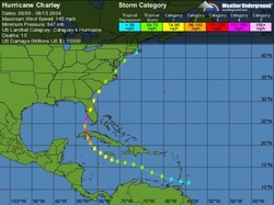 Figure 1
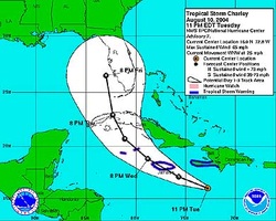 Figure 2A
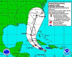 Figure 2B
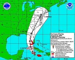 Figure 2C
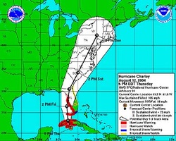 Figure 2D
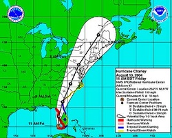 Figure 2E
|
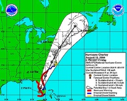 Figure 2F
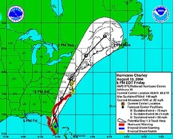 Figure 2G
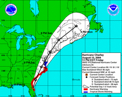 Figure 2H
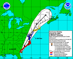 Figure 2I
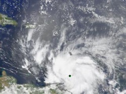 Figure 3
|
